Dispatch time 1-2 business days
Available delivery methods: DHL Express C, International Delivery, UPS Express Saver
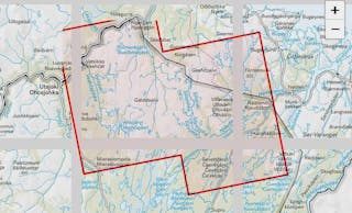
The map covering the stunning national landscape of Pallas and the northern part of Pallas-Yllästunturi National Park is a great planning tool for many hikes and treks. It is especially useful for planning stages of the Hetta-Pallas trail.
The map scale is 1:50,000 (1 cm on the map equals 500 meters in the terrain), and it also includes more detailed maps of the areas around Pallas and Hetta at a 1:25,000 scale. The Olos ski resort and its trails are also fully shown on the map.
In the north, the map shows the main village of Enontekiö, Hetta, along with its northern loop trails and Vuontisjärvi. On the eastern edge, Peltovuoma, Raattama, and Pallasjärvi are visible. The western edge includes the town of Muonio. In the south, the map extends to Äkäskero and Äkäsmylly.
The hiking map is based on the terrain data from the Finnish National Land Survey’s database, with added hiking information such as marked trails, rest stops, and service points.
The hiking maps are printed on lightweight and waterproof Tyvek material. The map withstands folding and tearing extremely well, and even when wet, it does not wear out but dries quickly.
The Pallas Hetta Olos hiking map was previously published by Karttakeskus. The outdoor information on the map was updated in 2025.
Model number | 623220 |
Web |
---|
20 |
Asiantuntijamme ovat keränneet blogikirjoituksiamme, jotka liittyvät tuotteeseen. Blogikirjoitukset voivat sisältää vinkkejä, ohjeita ja inspiraatiota.
{ "modelId": 54230, "manufacturer": { "name": "Karttakauppa", "slug": "karttakauppa", "logo": "https://scandinavianoutdoor.imgix.net/dynamic/manufacturers/N%C3%A4ytt%C3%B6kuva_2025-06-27_kello_7.58.20.png" }, "product": { "name": "Pallas Hetta Olos 1:50000/1:25000" }, "colors": [], "sizes": [], "types": [ { "name": "Regular", "slug": "regular" } ], "generalImages": [ { "caption": null, "path": "https://scandinavianoutdoor.imgix.net/dynamic/productimages/sizes/full/d5fd3f04-1edc-40db-9d69-b5b86ada88b6.jpeg" } ], "modelNotice": null, "description": "<p>The map covering the stunning national landscape of Pallas and the northern part of Pallas-Yllästunturi National Park is a great planning tool for many hikes and treks. It is especially useful for planning stages of the Hetta-Pallas trail.</p>\n<p>The map scale is 1:50,000 (1 cm on the map equals 500 meters in the terrain), and it also includes more detailed maps of the areas around Pallas and Hetta at a 1:25,000 scale. The Olos ski resort and its trails are also fully shown on the map.</p>\n<p>In the north, the map shows the main village of Enontekiö, Hetta, along with its northern loop trails and Vuontisjärvi. On the eastern edge, Peltovuoma, Raattama, and Pallasjärvi are visible. The western edge includes the town of Muonio. In the south, the map extends to Äkäskero and Äkäsmylly.</p>\n<p>The hiking map is based on the terrain data from the Finnish National Land Survey’s database, with added hiking information such as marked trails, rest stops, and service points.</p>\n<p>The hiking maps are printed on lightweight and waterproof Tyvek material. The map withstands folding and tearing extremely well, and even when wet, it does not wear out but dries quickly.</p>\n<p>The Pallas Hetta Olos hiking map was previously published by Karttakeskus. The outdoor information on the map was updated in 2025.</p>", "tagline": "A waterproof hiking map with Pallas, Hetta and Olos.", "properties": [], "quote": {}, "allowDiscount": false, "belongsToExtendedRange": false, "belongsToOutlet": false, "belongsToSkiWizard": false, "bindingSkiCombo": false, "blogPosts": [], "bundleModels": {}, "brand": "Karttakauppa", "brandSlug": "karttakauppa", "campaignOnly": false, "canonicalUrl": "https://scandinavianoutdoor.com/karttakauppa/gear/baps-and-books/maps-finland/pallas-hetta-olos-150000125000/", "activeDescription": "<p>The map covering the stunning national landscape of Pallas and the northern part of Pallas-Yllästunturi National Park is a great planning tool for many hikes and treks. It is especially useful for planning stages of the Hetta-Pallas trail.</p>\n<p>The map scale is 1:50,000 (1 cm on the map equals 500 meters in the terrain), and it also includes more detailed maps of the areas around Pallas and Hetta at a 1:25,000 scale. The Olos ski resort and its trails are also fully shown on the map.</p>\n<p>In the north, the map shows the main village of Enontekiö, Hetta, along with its northern loop trails and Vuontisjärvi. On the eastern edge, Peltovuoma, Raattama, and Pallasjärvi are visible. The western edge includes the town of Muonio. In the south, the map extends to Äkäskero and Äkäsmylly.</p>\n<p>The hiking map is based on the terrain data from the Finnish National Land Survey’s database, with added hiking information such as marked trails, rest stops, and service points.</p>\n<p>The hiking maps are printed on lightweight and waterproof Tyvek material. The map withstands folding and tearing extremely well, and even when wet, it does not wear out but dries quickly.</p>\n<p>The Pallas Hetta Olos hiking map was previously published by Karttakeskus. The outdoor information on the map was updated in 2025.</p>", "cleanDescrption": "The map covering the stunning national landscape of Pallas and the northern part of Pallas-Yllästunturi National Park is a great planning tool for many hikes and treks. It is especially useful for planning stages of the Hetta-Pallas trail.\nThe map scale is 1:50,000 (1 cm on the map equals 500 meters in the terrain), and it also includes more detailed maps of the areas around Pallas and Hetta at a 1:25,000 scale. The Olos ski resort and its trails are also fully shown on the map.\nIn the north, the map shows the main village of Enontekiö, Hetta, along with its northern loop trails and Vuontisjärvi. On the eastern edge, Peltovuoma, Raattama, and Pallasjärvi are visible. The western edge includes the town of Muonio. In the south, the map extends to Äkäskero and Äkäsmylly.\nThe hiking map is based on the terrain data from the Finnish National Land Survey’s database, with added hiking information such as marked trails, rest stops, and service points.\nThe hiking maps are printed on lightweight and waterproof Tyvek material. The map withstands folding and tearing extremely well, and even when wet, it does not wear out but dries quickly.\nThe Pallas Hetta Olos hiking map was previously published by Karttakeskus. The outdoor information on the map was updated in 2025.", "unTranslatedDescription": null, "metaDescription": "A waterproof hiking map with Pallas, Hetta and Olos. The map covering the stunning national landscape of Pallas and the northern part of Pallas-Yllästunturi National Park is a great planning tool for many hikes and treks.", "isSingleColor": true, "isPublic": true, "isBundle": false, "promotedColour": null, "giftCardTemplates": [], "groups": [ "maps-finland" ], "groupFrom": [ "gear", "baps-and-books", "maps-finland" ], "logo": "https://scandinavianoutdoor.imgix.net/dynamic/manufacturers/N%C3%A4ytt%C3%B6kuva_2025-06-27_kello_7.58.20.png", "mainGroup": { "name": "Maps, Finland", "path": "/gear/baps-and-books/maps-finland/" }, "modelGroupParents": [ { "id": 62, "name": "Gear & Equipment", "slug": "gear" }, { "id": 112, "name": "Maps and books", "slug": "baps-and-books" } ], "modelPath": "/karttakauppa/gear/baps-and-books/maps-finland/pallas-hetta-olos-150000125000/", "name": "Pallas Hetta Olos 1:50000/1:25000", "prices": { "active": 15.856573705179283, "reference": null, "club": null, "original": 15.856573705179283, "type": "regular", "ribbon": null }, "taxClass": 5, "rating": { "average": 0, "count": 0 }, "sizeTablePath": false, "skiWizard": { "group": "", "sport": "" }, "slug": "pallas-hetta-olos-150000125000", "activeTagline": "A waterproof hiking map with Pallas, Hetta and Olos.", "unTranslatedTagline": null, "tags": [], "modelNumber": "623220", "uuid": "d1c99fda-ef31-4f56-a603-97ec870be960", "priceEnding": null, "shelfCode": null, "shelfCodeTwo": null, "shelfCodeThree": null, "shelfCodeFour": null, "shelfCodeFive": null, "shelfCodeSix": null, "variantPrices": false, "secondHandParent": null, "variants": [ { "prices": { "active": 15.856573705179283, "reference": null, "club": null, "original": 15.856573705179283, "type": "regular", "ribbon": null }, "colorSlug": null, "isBackorderable": false, "isOrderable": true, "orderableQuantity": 20, "storeAvailability": [ { "storeId": 10, "storeSlug": "forum", "quantity": 0 }, { "storeId": 7, "storeSlug": "pirkkala", "quantity": 0 }, { "storeId": 4, "storeSlug": "pori", "quantity": 0 }, { "storeId": 6, "storeSlug": "kuninkoja", "quantity": 0 }, { "storeId": 2, "storeSlug": "salo", "quantity": 0 }, { "storeId": 9, "storeSlug": "tammisto", "quantity": 0 }, { "storeId": 20, "storeSlug": "scandinavianoutdoor", "quantity": 20 } ], "inStockStores": [ { "name": "Verkkokauppa", "slug": "scandinavianoutdoor", "pikanouto": false, "nouto": true } ], "onlyFromExtStock": false, "color": "", "colorControl": "", "variantId": 314392, "teksoNumber": "9789527623220", "inStock": true, "detailedStocks": { "2": 0, "4": 0, "6": 0, "7": 0, "9": 0, "10": 0, "20": 20 }, "inAssaStorage": true, "modelName": "", "modelId": 54230, "onOrder": true, "shippingTimeDays": "1-2", "shippingTimeString": "Dispatch time 1-2 workdays", "shippingTimeNumber": 2, "size": null, "sizeSort": null, "sizeSlug": null, "type": "Regular", "typeSort": null, "typeTitle": "Type", "typeSlug": "regular", "stockIncoming": null, "blockedStock": false } ], "allowedDeliveryMethods": [ "DHL Express C", "International Delivery", "UPS Express Saver" ], "isDeliveryCountryBlocked": false, "isDeliveryMethodLimitations": false, "perInternationalPackage": null, "deliveryBlockInfoText": null, "bundles": [], "uniqueSizetablePaths": [], "sizeTables": [] }